Introduction
Flash floods pose a significant challenge in Bangladesh, particularly in areas prone to flooding, such as the Sylhet Haor Basin. It is especially susceptible due to its topography, excessive rainfall, and poor drainage system. Besides destroying local infrastructure and agriculture, flash floods also impact livelihoods, particularly in rural areas where agriculture contributes significantly to the economy. This blog examines the causes, effects, and possible countermeasures of flash floods in Sylhet, drawing on information from three recent articles that focus on sensitivity, vulnerability, and management of these disasters.
Study Area
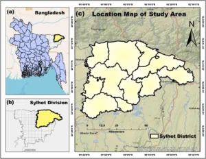
The Sylhet district is situated within the geographical coordinates of 24°36′ and 25°11′ north latitudes and 91°38′ and 92°30′ east longitudes, illustrated in Fig. 1. Sylhet district covers an area of 3490 km2. In the north and west, it shares international borders with India, and its topography is defined by the Surma valley, which includes the Surma and the Kushiyara rivers. The Sylhet district, known as the northeastern lowland, is situated in the northeastern region of Bangladesh.

Fig. 1 Study area with location map. (a) Map of Bangladesh; (b) Map of Sylhet division; (c) Map of Sylhet district. [3]

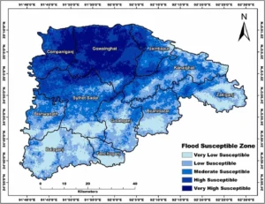
Fig. 2 Flood susceptibility map of Sylhet district
What is a Flash Flood?
A flash flood is a violent temporary flood that generally happens in six hours after a heavy rain or some other terrible weather conditions. When compared to the normal floods, flash floods occur as a result of very short notice and mostly communities are caught unawares. These sudden and fierce floods have the capacity of overpowering the drainage systems, filling roads causing mayhem to infrastructure, and are, therefore, among the most devastating natural calamities. Flash floods are highly dangerous and cataclysmic since they happen rapidly and the water is very powerful.
The most common cause of flash flood is high rainfall intensity in a short time especially in regions where there is already poor drainage system. Flash floods may be caused by other factors that include dam or levee failure, fast snowmelt, or even by landslides. The flood increases fast and flows into the lowlands, into the valleys, into the alleys and even the city streets, where the overflow of water does not know where to go. Consequently, urban environments are often the victims of flash floods more so since the built surfaces such as roads and the structure do not allow the surplus rainwater to soak into the ground.
The floods are local so to say, they are frequently restricted to minor regions but are extremely violent and may be incredibly devastating. Water may come up with a terrifying velocity and turn streets into rivers and cleaning everything in its way. These flash floods tend to destroy homes, cars, bridges, and crops. The force of the water may also pose hazardous conditions since it sweeps the debris and is capable of sweeping anything to vehicles, trees and even human beings.
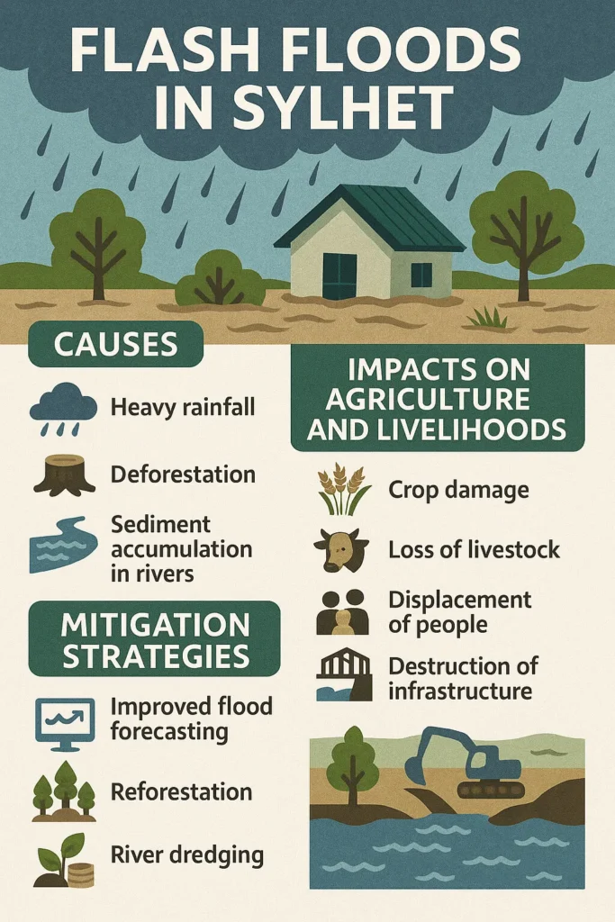
All variants of flash flood are also notorious in Sylhet in northeastern part of Bangladesh and these flash out with little warning and result with enormous destruction. The cause of flash floods is normally rain (severe rainfall focused on one place) that causes rapid water movement contributing to congestion in rivers and canals within the locality. All these floods have been compounded by failure in the effective flood control measures like the poor dredging of rivers and canals. What Sylhet and more precisely the Sylhet Haor Basin are experiencing is an augmenting and severity of flash floods, which is due to its topography that is low lying as compared to the rest of the country and bad natural capacities to convey water [1].
Communities in flood prone areas need to know what causes, risks, and early warning signs of flash floods and what to do to combat this disastrous flash floods. The effectiveness of flood management strategies and maintenance of early warning systems and preparing prior plans by using floods can be very effective in averting the disastrous consequences of flash floods.
Impacts on Livelihoods and Agriculture
The economy of the Sylhet Haor Basin depends mainly on agriculture and rice is the major staple. Nevertheless, flash floods are calamitous to agricultural yields. Assert that flash floods often destroy rice crops at harvest stage, which is a most crucial stage to the local farmers who use their crop yields to earn their income [1]. In other instances, such floods lead to total loss of crops that worsen the challenge of food insecurity and poverty.
The perspectives of the 2022 flash flood in Sylhet in terms of its social and economic consequences, and more specifically on the association of vulnerability and disaster destruction [2]. They found out that the flood-prone communities of Sylhet faced severe economic consequences, the main ones being a loss of fields and agricultural infrastructure. This disturbance does not only drop production of crops, it also drops revenue and drives several families into different forms of livelihoods, which are, in many cases, less stable. The research has outlined that poor communities that have less resources and possess a low level of adaptability are prone to prolonged socio-economic effects after a flash flood [2].
Mitigation Strategies
Considering that flash floods have become regular phenomena in Sylhet, it is necessary to have adequate flood risk management approaches. It will take a combination of both structural and non-structural mitigation inputs to reduce the effects of these floods. That one of the methods to alleviate the impact of flash floods on agricultural land and communities is the creation of stronger embankments and flood barriers. Although they are expensive, these measures would be useful in minimizing the flood damages especially in regions that are likely to be heavily flooded [1].
Along with physical barriers, Khan et al. [2] also highlighted the role of non-structural ones, i.e. consequently enhancing disaster preparedness and community resilience. In their research, they discovered that regions that greatly enjoyed access to early warning systems and mechanisms of disaster response were also the regions that recovered faster in case of flash floods. As such, early warning infrastructure and sensitization within the community about how to prepare against floods are essential in reducing the impacts of floods and their losses.
Moreover, advanced modeling tools; like GIS and AHP could also aid the authorities in defining the flood-prone regions and prioritize flood mitigation services. The research conducted by Shadmaan and Hassan animated the policy-conducting role that flood susceptibility maps, which utilize GIS technologies, could play in determining the most vulnerable areas [3]. When vulnerability information is combined with these maps, disaster management agencies can make better decisions regarding which resources to allocate where and how to increase flood resilience to the most susceptible communities.
Conclusion
In Sylhet, flash floods are disastrous to agriculture, infrastructure and local livelihoods. These impacts can however be mitigated by integrating structural measures like embankments and flood barriers with non-structural measures like enhancement of the early warning systems and community mobilization into preparedness. In addition, vulnerability profiles such as the Livelihood vulnerability index and flood susceptibility mapping via GIS could be used to offer meaningful insights on focused risk reduction measures. With a multi-pronged approach to the management of floods, Sylhet will be better geared to control future flash floods and overcome the long-term societal and economic impacts of the natural occurrences.
References
[1] M. Akter, M. R. Islam, M. A. Karim, M. G. Miah, and M. M. Rahman, “Impact of flash floods on agri-based livelihoods in Sylhet Haor Basin,” Ann. Bangladesh Agric., vol. 26, no. 1, pp. 61-73, 2022.
[2] E. M. Talid Khan, A. S. M. Maksud Kamal, M. Kabir, S. M. Kamrul Hassan, T. Hayat, and A. K. F. Fahim, “An empirical study to develop a relationship between vulnerability and disaster damage and loss for Sylhet flood 2022,” Discover Applied Sciences, vol. 7, pp. 493, 2025.
[3] M. S. Shadmaan and K. M. Hassan, “Assessment of flood susceptibility in Sylhet using analytical hierarchy process and geospatial technique,” Geomatica, vol. 76, pp. 100003, 2024.


